The Stelvio Pass by racing bike
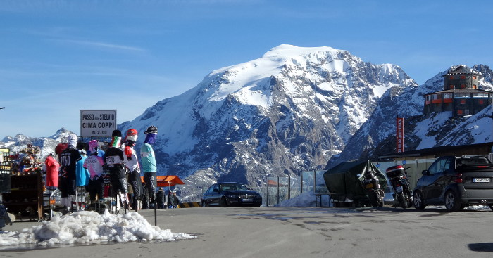
The Stelvio Pass is 2758 m asl and links Lombardy to Switzerland and the South Tyrol, only during the summer season) along the highest metalled mountain roads in Europe.
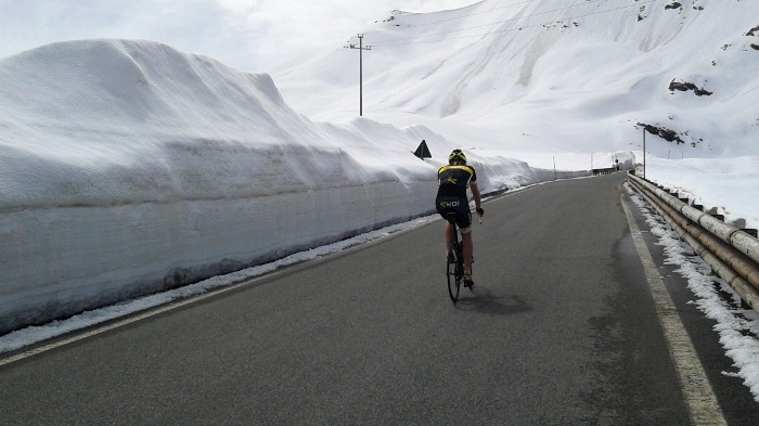
The Stelvio Pass usually opens in the second half of May and closes during the first days of November.its roads are in The Stelvio National Park, an area steeped in history.
The history attached to the First World War comes from when the Stelvio Pass was at the forefront of the fighting, the remains of the foxholes,trenches and gun sites still bear witness to this sad,difficult and hard period in time.
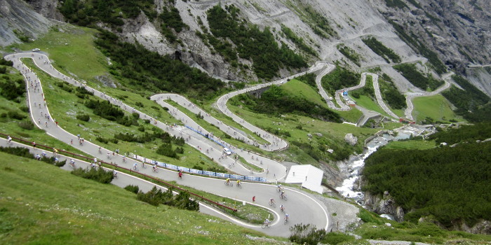
The history of cycling comes from the epic achievements reached during the historical moments of the Giro d'Italia (Tour of Italy).
There are three cycle routes to the Stelvio Pass: the South Tyrolean side, from Prato allo Stelvio, the Lombardia side from Bormio and the Swiss side from Santa Maria (in Val Monastero) over the Umbrail Pass.

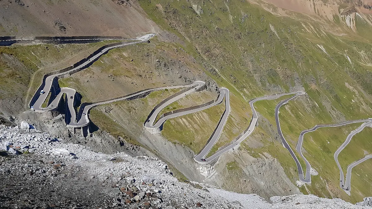
The climb from Prato allo Stelvio.
The South Tyrol ascent is the hardest climb. The starting point is Prato allo Stelvio (918 m asl) and the climb is 25 km long, with an ever increasing gradient in the slopes.
The first 8 km are the easiest, with an average gradient of around 5%. After a slight short climb you’will begin to encounter the first of the 48 hairpin bends and a slightly more challenging gradient of 8%. Once you leave Trafoi behind you, the gradient in the uphill climb becomes more challenging, but the stunning views of the Ortler mountains help you to overcome your fatique.. The final part of the climb is very regular, but maximum effort is still required to conquer those last hairpin bends.
The bends are numbered backwards, from the Pass so that you always know how far you are from the top!
The average gradient is 7.4%, the maximum gradient is 11% and the vertical drop is more than 1800 m.
Details of the climb:
- Length: 25 km
- Hairpin bends: 48
- Starting altitude: 918 m
- Arrival altitude: 2758 m
- Elevation gain: 1842 m
- Slope: 7,2% (Max 14%)
Map, detailed information and gps file of the ascent to Stelvio Pass from Prato.
The climb from Bormio.
The ascent from the Lombardia side begins in Bormio 1,225 m.asl and is 21 km long.
The climb starts immediately with a challenging gradient and in parts you really ' catch your breath '. After about 8 km you will find a number of small tunnels hewn out of the rock, always well lit 24 hours a day, more challenging steep slopes, up to 14%, follow on from the tunnels..Now you have reached the central part of the climb to the Stelvio Pass, where,after a series of hairpin bends, you are getting always closer to the top.
After 15 km you reach a moderate part of the ascent lasting about one kilometre, from here you can see the final part of the climb to the Stelvio Pass, The last 4 kms are the hardest and most demanding with a gradient of over 8%.
The average gradient is 7.3%, the maximum is 14% between km 10 and 11, the vertical drop is more than 1500 m.
Details of the climb:
- Length: 21,5 km
- Hairpin bends: 42
- Starting altitude: 1215 m
- Arrival altitude: 2758 m
- Elevation gain: 1533 m
- Slope: 7,1% (Max 14%)
Map, detailed information and gps file of the ascent to Stelvio Pass from Bormio.
The climb from Santa Maria over the Umbrail Pass.
The third ascent to the Stelvio Pass is for the most part in Switzerland and on Swiss roads. The starting point is in Santa Maria 1375 m asl in the Val Monastero, part of the Grison Federation, and is about 16 km long.
The road from Santa Maria to the Umbrail Pass 2503 m asl, on the Italian-Swiss border, is about 13 km long. It is a narrow,well maintained road, the last 500 mt are on a well packed dirt road which has become a feature of this climb. The uphill climbs are challenging and there are several hairpin bends.
Once you get to the top of the Umbrail pass, only 4 km and about a 250 m vertical drop separate you and your bike from the Stelvio Pass.
The average gradient is around 8% and the vertical drop is almost 1400 m.
Details of the climb:
- Length: 15,4 km
- Starting altitude: 1372 m
- Arrival altitude: 2496 m
- Elevation gain: 1372 m
- Slope: 10,1%
Map, detailed information and gps file of the ascent to Umbrail Pass from Santa Maria.
More information
The Stelvio Pass is a popular destination for many cyclists, who challenge themselves on the saddle of their road bicycle on the mountains made epic by the stages of the Tour of Italy.

What events on the Stelvio?
Every summer, on the roads leading to the Stelvio Pass, cycling events are organized, which always attract many enthusiasts:
- The granfondo dello Stelvio Santini at the beginning of June
- The Mapei Day - King Stelvio in mid-July
- The Stelvio Day at the beginning of September
How long does it take to cross the Stelvio Pass by bike?
It depends a lot on the slope and the degree of training.
From Bormio you can climb in a time between1 and a half to 2 and a half hours.
From the Prato side, the climb takes between 2 and a half and 3 and a half hours.
How much does the pass open and close?
The Stelvio pass generally opens not before mid-May and always closes at the beginning of November.
During the summer season, the pass may be closed due to bad weather.
How many bends are there on the Stelvio?
From the Bormio side there are 42 hairpin bends, while from the Prato side there are 48 hairpin bends.
Watch the video of the ascent to Pass of the Stelvio.